Plan your next cycling trip to work or for recreation.
On this page
Online journey planner
Try out the Cycle Instead Journey Planner for Adelaide on your PC, tablet or smartphone. Based on the Bikedirect network, this interactive tool helps you plan your cycling trip using a variety of options that consider fitness, confidence level, road conditions and speed of travel.
Bikedirect cycling maps
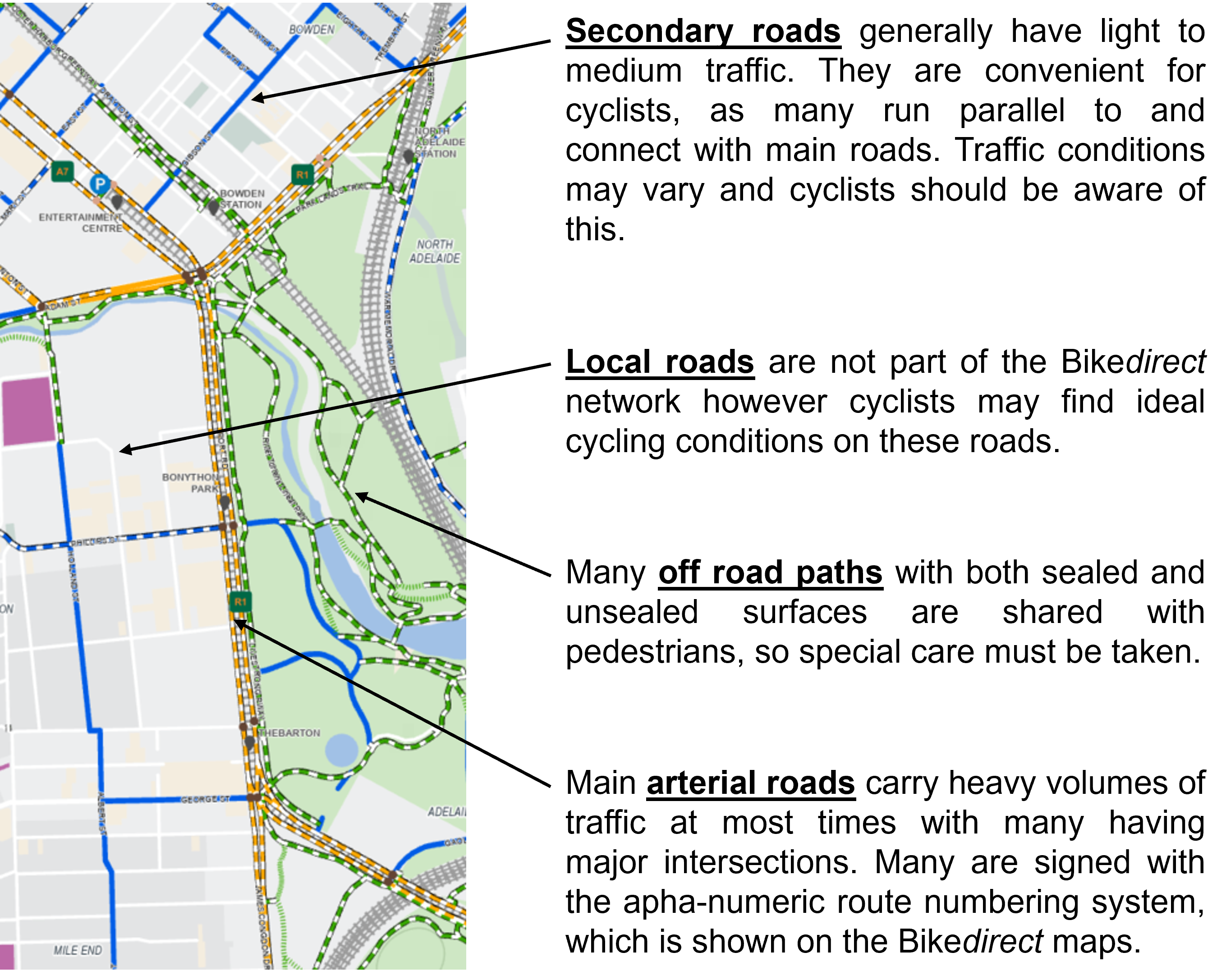
Bikedirect is a network of bicycle routes across the Adelaide metropolitan area. The maps provide options for people with different needs and abilities and show main roads, bicycle lanes, local streets and off-road paths.
These maps updated in 2024, are no longer available in hard copy:
- Bike map one - Munno Para to Gawler (1.1 MB PDF)
- Bike map two - Elizabeth South to Munno Para (1.5 MB PDF)
- Bike map three - Golden Grove and Elizabeth Downs (1.8 MB PDF)
- Bike map four - Mawson Lakes and Modbury Heights to Elizabeth South (2.0 MB PDF)
- Bike map five - Woodville to Outer Harbour (1.4 MB PDF)
- Bike map six - Adelaide City to Mawson Lakes (and eastern suburbs) (2.3 MB PDF)
- Bike map seven - Rostrevor to Golden Grove (2.2 MB PDF)
- Bike map eight - Morphetville to Woodville (1.9 MB PDF)
- Bike map nine - Mitcham to Maylands and city centre (2.2 MB PDF)
- Bike map 10 - Happy Valley to Edwardstown (including coast) (2.0 MB PDF)
- Bike map 11 - Hackham to O'Halloran Hill (including coast) (1.8 MB PDF)
- Bike map 12 - Maslin Beach to Port Noarlunga (1.4 MB PDF)
- Bike map 13 - Aldinga to Maslin Beach (1.2 MB PDF)
- Adelaide CBD bike map (2.4 MB PDF)
People using the Bikedirect maps do so at their own risk. DIT will not accept any responsibility for any personal injury or damage to property arising from using these maps. Every care has been taken in the preparation of these maps, however no responsibility is accepted for any errors or omissions.
Maps can be printed on standard A3 or A4 paper.
Cycling and walking maps
Five cycling and walking maps cover the Adelaide metropolitan area. The maps show bike lanes, local streets and shared use paths, as well as signalled intersections, pedestrian crossings and school crossings to help plan your cycling or walking trip. They also include information so you can estimate approximate travel times.
Cycling trails
Maps and information about the network of cycling trails in South Australia can be found on the Trails SA website. Information includes distance, time and rating by difficulty.